


Future Station Area Master Plans
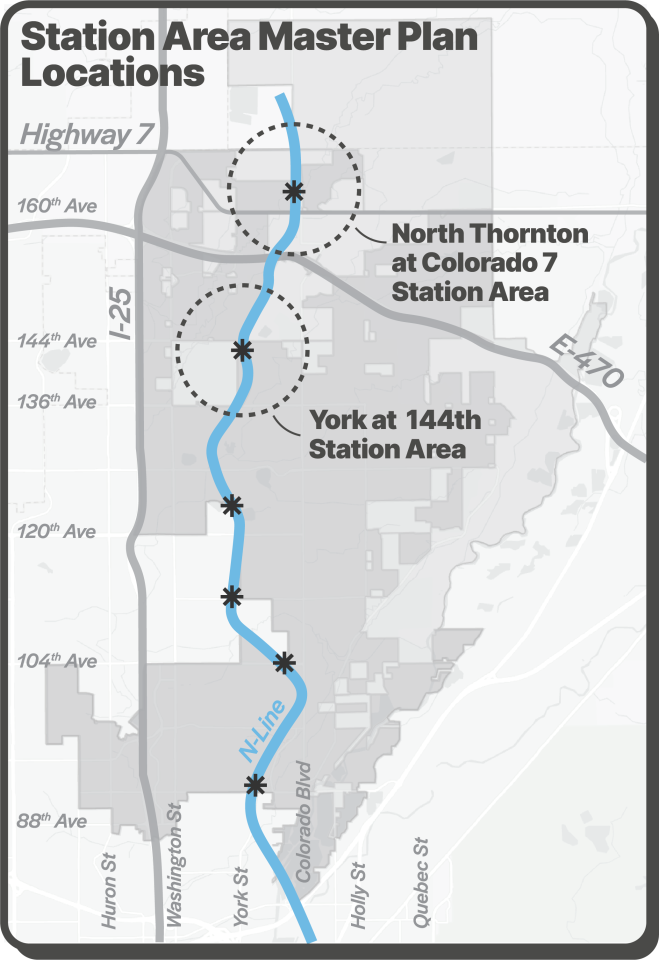
The city is beginning outreach and planning for two Station Area Master Plans (STAMPs) on the north side of Thornton. The plans will prepare for RTD’s planned completion of the N Line to the future stations at York at 144th and North Thornton at Colorado (CO) 7. These plans will consider a broad range of topics and how they inter-relate including land use, transportation and infrastructure, and economic development in order to create a cohesive long-term vision for the Station Areas.
These planning processes will involve community engagement throughout the project to ensure participation from residents and businesses. You can follow along with the project and receive updates by providing your contact information to the Newsletter below.
York at 144th Project Page North Thornton at CO 7 Project PageSign up for the Project Newsletter!
Overview
The N-Line commuter rail opened in 2020, activating four stations within the city limits. Capitalizing on the opportunities of the transit service includes providing a vision and planning framework for future private development and public investment in the areas directly surrounding the transit stations; the documents created through this process are called Station Area Master Plans, commonly referred to as STAMPs.
These plans will serve as a blueprint for policy, regulatory and investment decisions needed to make transit-oriented development (TOD) in these Station Areas a reality. These plans establish flexible frameworks for private investment in development and redevelopment, while providing appropriate guidance related to the types of land uses, transportation infrastructure, and area amenities desired by the community.
On this page
Original Thornton at 88th STAMPThornton Crossroads at 104th STAMP112th Avenue STAMPEastlake at 124th STAMPAdditional Resources

Original Thornton at 88th Station Area Master Plan
Located near 88th Avenue and Welby Road, this is the southernmost N Line station in Thornton. As a transit gateway into Thornton, this station provides a unique opportunity to create a positive impression and image of Thornton to visitors and residents. This STAMP (adopted in 2015) provides a vision and planning framework for future private development and public investment in order to create a vibrant, walkable station area with convenient train access.
Original Thornton at 88th STAMP [PDF/7.2MB]

Thornton Crossroads at 104th Station Area Master Plan

This STAMP for the area around the station at 104th Avenue and Colorado Boulevard was adopted in 2015. Within this area, land use alternatives were created for four opportunity sites that are particularly feasible for development or redevelopment. The plan focuses on creating a walkable station area with a rich mix of land uses within a half-mile walking distance of the station.
112th Avenue Station Area Master Plan
Although the station is located within Northglenn, much of the adjacent vacant land is located within Thornton. The two jurisdictions worked together on this STAMP that was adopted in 2017 by the Thornton City Council. The plan aims to create a mixed-use, walkable TOD.
112th Avenue STAMP [PDF/68.2MB]City of Northglenn 112th Station Website

Eastlake at 124th Station Area Master Plan

The town of Eastlake was originally settled as a railway village in the early 20th century and incorporated into the city of Thornton in 1990. The 2015 Eastlake at 124th STAMP takes advantage of the existing main street and small- lot grid creating an ideal environment for TOD. This station is the temporary end of line for the N Line.